- Klientu atbalsts katru dienu 9-21:00 Bezmaksas tālrunis: 800 3686 Bezmaksas tālrunis 9-21:00 800 3686 Veikali
-
Piegādāt uz · Latvijas
-
-
Photopoint starptautiskās vietnes:
-
-
Mans konts
-
Mans Photopoint
Pierakstīties personīgajā Photopoint kontā
-
Jauns klients?
Izveidot kontu
-
Prece ir veiksmīgi pievienota Jūsu iepirkumu grozam
Jūsu iepirkumu grozā ir 0 preces. Jūsu iepirkumu grozā ir 1 prece.
Monthly payment starting from 5 €
Fill in the hire purchase application in checkout
Pievienojiet 99 € un saņemiet bezmaksas piegādi uz pakomātu vai ar kurjeru
-
Kameras
- Canon spoguļkameras
- Nikon spoguļkameras
- Pentax spoguļkameras
- Fujifilm Instax instant cameras
- Polaroid tūlītējās drukas kameras
- Canon instant cameras
- Kodak instant cameras
- DJI kameru droni
Top spoguļkameras
Top tūlītējās drukas kameras
Top kameru droni
- Sony bezspoguļa kameras
- Fujifilm bezspoguļa kameras
- Panasonic bezspoguļa kameras
- Olympus bezspoguļa kameras
- Canon bezspoguļu kameras
- Nikon bezspoguļu kameras
- Sony pilnkadra bezspoguļu kameras
- Panasonic full-frame mirrorless cameras
- Nikon full-frame mirrorless cameras
- Canon pilnkadra bezspoguļu kameras
Top bezspoguļa kameras
Top full-frame mirrorless cameras
- 0 - 25 €
- 25 - 100 €
- 100 - 250 €
- 250 - 500 €
- 500 - 1000 €
- 1000 - ... €
- Canon
- Nikon
- Pentax
- Sony
- Fujifilm
- Olympus
- Panasonic
- GoPro
- Polaroid
- Ricoh
Cenas diapazons
Zīmols
-
Foto
- Objektīvi
- Filtri
- Telekonverteri
- Pagarinājuma gredzeni
- Objektīvu pārsegi
- Objektīvu adapteri
- Objektīvu maciņi
- Video apgaismojums
- Zibspuldzes
- Flash triggers
- Statīvi
- Statīvu galvas
- Monopodi
- Kameru stabilizatori
- Visi foto
Objektīvi un piederumi
Zibspuldzes un video gaismas
Statīvi
- Kameru mikrofoni
- Video monitori
- Tālvadība
- Bateriju bloki (Grip)
- Piedzīvojumu kameru piederumi
- Atmiņas kartes
- USB zibatmiņas
- Ārējie cietie diski
- Optiskie diski
- Filmiņas
- Atmiņas karšu lasītāji
- Fotosomas
- Camera straps
- Lietus pārsegi
Kameru piederumi
Datu nesēji
Kameru somas un piederumi
- Fotorāmji
- Foto albumi
- Paspartū
- Foto kastes
- Foto līmlapiņas un līmes
- Display protection
- Sensor cleaning
- Cleaning kits
- Cleaning wipes
- Lenspens
- Cleaning fluids
- Foto ķīmija
- Fotopapīrs
- Laboratorijas piederumi
Arhivēšanas piederumi
Tīrīšanas un aizsardzības līdzekļi
Laboratorijai
-
Datori & IT
-
Elektronika
-
Māja un dārzs
- Brīvi stāvošās plītis
- Iebūvējamās plīts virsmas
- Iebūvējamās cepeškrāsnis
- Mikroviļņu krāsnis
- Trauku mazgājamās mašīnas
- Blenderi
- Ledusskapji
- Saldētavas
- Kafijas automāti
- Tējkannas
- Virtuves kombaini
- Sulu spiedes
- Mikseri
- Rokas blenderi
- Termopodi
- Kafijas pupiņas un kapsulas
- Veļas mašīnas
- Žāvēšanas mašīnas
- Visi māja un dārzs
Virtuvei
Vannas istabai
- Televizori
- Mediju atskaņotāji
- HiFi un mājas kinozāles
- Spēļu konsoles
- Putekļu sūcēji
- Putekļu sūcēji roboti
- Filtru maisiņi
- Gludekļi
- Skrūvgrieži
- Elektriskie skrūvgrieži
- Urbji ar vadu
- Bezvadu urbji
- Diska slīpmašīnas
- Cirkulārie zāģi
- Instrumentu komplekts
Dzīvojamai telpai
Citas mājas ierīces
Elektroinstrumenti
-
Skaistums
- Sieviešu smaržas
- Sieviešu tualetes ūdeņi
- Sieviešu odekoloni
- Komplekti sievietēm
- Vīriešu smaržas
- Vīriešu tualetes ūdeņi
- Vīriešu odekoloni
- Komplekti vīriešiem
- Unisex smaržas
- Unisex odekoloni
- Sauļošanās līdzekļi
- Saules aizsardzības līdzekļi
- Krēmi pēc sauļošanās
- Visi skaistums
Sieviešu aromāti
Vīriešu aromāti
Unisex aromāti
Iedegumam
- Dušas želejas
- Dezodoranti
- Soaps
- Disinfectants
- Ķermeņa losjoni
- Ķermeņa krēmi
- Roku krēmi
- Epilatori
- Hair removal
- Massage devices
- Sejas krēmi
- Serumi sejas ādai
- Sejas maskas
- Acu krēmi
- Face scrubs
- Sejas attīrīšana
Higiēna
Ķermeņa kopšana
Sejas kopšana
- Lūpu krāsas
- Lūpu spīdumi
- Tušas
- Acu ēnas
- Acu laineri
- Pūderi
- Tonālie krēmi
- Konsīleri
- Grima noņēmēji
- Šampūni
- Kondicionieri
- Matu griežamās mašīnītes
- Matu taisnotāji
- Matu rullīši
- Fēni
- Prezervatīvi
- Lubrikanti
- Rotaļlietas un vibratori
Kosmētika
Matu kopšana
Seksuālā veselība
- Elektriskās zobu birstes
- Oral irrigators
- Toothpastes
- Skuvekļi
- Beard trimmers
- Beard care
- Skuvekļi
- Nagu lakas
- Nail files
- Manikīra un pedikīra komplekti
- Foot baths
- Sunglasses
- Blue light glasses
- Rotaslietas
Mutes dobuma kopšana
Bārdas kopšana
Manikīrs un pedikīrs
Piederumi
-
Sports un hobiji
- Viedpulksteņi
- Viedaproces
- Sporta pulksteņi
- Sports watch and smartwatch straps
- Rokas GPS
- Pulsometri
- Velosipēdi
- Tricikli
- Skūteri
- Skrituļslidas
- Fitness
- Trenažieri
- Vingrošanas zāles aprīkojums
- Sporta somas
- Nutikaalud
- Svari
- Tonometri
- Termometri
- Visi sports un hobiji
Sporta pulksteņi
Sporta preces
Veselības ierīces
- Elektriskie skrejriteņi
- Elektriskie velosipēdi
- Balansa skūteri
- Skrituļdēļi
- Sporta krekli
- Sporta bikses
- Sports shoes
- Tracksuits
- Sweatshirts
- Jackets
- Swimming clothes
- Ski wear
- Cycling clothing
- Thermoactive underwear
- Fishing supplies
- Art supplies
- Handicrafts
- Numismatics
- Philately
Transportlīdzekļi
Sports clothing
Hobiji
- Dārza instrumenti
- Dārza elektroinstrumenti
- Bezvadu urbji
- Lööktrellid
- Urbji ar vadu
- Skrūvgrieži
- Instrumentu komplekts
- Multiinstrumenti
- Cirkulārie zāģi
- Diska slīpmašīnas
- Liimipüstolid
- Levels
- Measuring tapes
- Screws, nails, plugs etc
- Work clothes
- Viss kategorijā "Instrumenti"
- Lietie diski
- Riepas
- Auto spuldzes
- Vējstikla tīrītāji
- Rezerves daļas
- GPS
- Viss kategorijā "Auto preces"
Izdari pats
Auto preces
-
Rotaļlietas
- Tālvadības rotaļlietas
- Automašīnas ar tālvadību
- Lidmašīnas ar tālvadību
- Droni
- Āra spēles
- Pludmales rotaļlietas
- Liivakasti mänguasjad
- Toy and water guns
- Braucamās rotaļlietas
- Lecambumbas
- Bumbas
- Mullitajad
- Spēļu mājiņas un slidkalniņi
- Šūpoles
- Visi rotaļlietas
Tālvadības rotaļlietas
Sports un āra spēles
- LEGO
- LEGO Duplo
- Citi rotaļu klucīši
- Rokdarbu komplekti
- Attīstošās rotaļlietas
- Mākslas preces
- Muzikālās rotaļlietas
- Robootika komplektid
- Lelles
- Doll clothes
- Doll accessories
- Rotaļu figūriņas
Rotaļu klucīši
Bērnu daiļrade
Lelles
- Mīkstās rotaļlietas
- Karuseļi gultiņām
- Vannas rotaļlietas
- Grabulīši
- Bērnu puzles
- Kožamās rotaļlietas
- Bērnu spēļu paklāji
- Aktivitāšu centri
- Puslematid
- Toy cars
- Mängurongid
- Sacīkšu auto
- Models
- Model paints and supplies
Zīdaiņiem un mazuļiem
Rotaļu mašīnītes
- Galda spēles
- Puzles
- 3D puzles
- Kāršu spēles
- Spēļu kārtis
- Interaktīvās rotaļlietas
- Kids' role playing toys
- Citas rotaļlietas
Galda spēles un puzles
Kāršu spēles
Citas rotaļlietas
-
Auto
- Balansa skūteri
- Elektriskie skrejriteņi
- Elektriskie velosipēdi
- ATV
- Instrumentu komplekts
- Sprūdrata uzgriežņu atslēgas
- Ietveres
- Uzgriežņu atslēgas
- Gredzenu uzgriežņu atslēga
- Skrūvgrieži
- Auto remonta instrumenti
- Domkrati
- Augstspiediena mazgātāji
- Darba apgaismojums
- Viss kategorijā "Instrumenti"
Transportlīdzekļi
Elektroinstrumenti
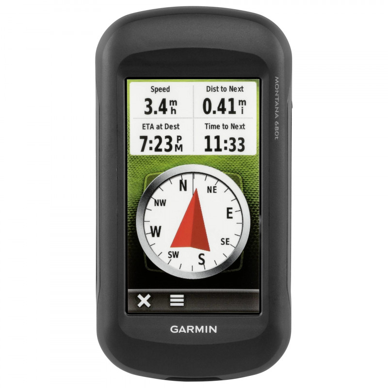


Garmin Montana 680t with Recreational Map of Europe
14-152763

Pamatinformācija
Garmin Montana 680tThe handheld GPS to go anywhere and everywhere GPS and GLONASS - faster and better satellite fix 4" outdoor optimised, dual orientation display for easy readability under any condition Comes with great content preinstalled - RecreaPrece ir arhivēta
Garmin Montana 680t
The handheld GPS to go anywhere and everywhere
- GPS and GLONASS - faster and better satellite fix
- 4" outdoor optimised, dual orientation display for easy readability under any condition
- Comes with great content preinstalled - Recreational Map of Europe, 250k geocaches from Geocaching.com and 1 year free BirdsEye Satellite Imagery*
- Adds Track Manager for better user experience and more control
- 8MP camera - for high resolution geotagged pictures
- Most versatile navigation everywhere - most versatile features, display and mounting
- Barometric altimeter and 3-axis compass
Designed for use on the trail, on road or on the water, the Montana 680t from Garmin will guide you wherever you go. With a vast 4" sunlight-readable touchscreen that offers crystal clear enhanced colours, dual orientation display and GPS and GLONASS positioning to track your location quicker and more accurately, even in the most challenging environment. It's easy to see where you are at all times and conveniently control your track recording with the Track Manager. Montana 680t includes a 3-axis electronic compass with barometric altimeter and comes with a free 1-year BirdsEye Satellite Imagery subscription*. Both durable and waterproof (IPX7, up to 1 metre, 0,1 ATM), Montana 680t adds a 8 MP camera and is built to withstand the elements.**
See the big view
Montana 680t features a 4" outdoor optimised, dual orientation touchscreen display that offers best readability under any light condition. The easy-to-use touch screen user interface means you'll spend more time enjoying the outdoors and less time searching for information. Adventurers love the extra-large display of Montana that provides great readability due to big data fields and clearly visible map features. Both durable and water resistant, Montana 680t is built to withstand the elements. Bumps, dust, dirt, humidity and water are no match for this rugged navigator.**
Take Geotagged Pictures
Capture locations and memories with Montana 680t's upgraded 8 megapixel digital camera. Each photo is geotagged automatically with the location of where it was taken, allowing you to navigate back to that exact spot in the future. Snap and view pictures in landscape or portrait orientation. Keep track of your photos and see their locations on a map using BaseCamp(TM). Insert a microSD(TM) card for more photo storage or to view pictures from other devices.
Keep Your Fix
With the high-sensitivity GPS and GLONASS receiver, Montana 680t locates your position quickly and precisely and maintains its location even in thick forest and deep valleys. The advantage is clear - whether you're under heavy tree cover or just near tall buildings and trees, you can count on Montana 680t to help you find your way when you need it the most.
Go Anywhere
With an array of compatible mounts, Montana is designed for use on bicycles, in 4x4s, on boats and as a handheld or for convenient everyday navigation in your car. Use the optional auto mount with City Navigator maps for spoken, turn-by-turn driving directions, or try out the optional rugged mount for your motorcycle or ATV.
Überall unterwegs
Montana 680t comes with an 1-year BirdsEye Satellite Imagery subscription for great aerial images to enhance your navigation, in case you want more detailed information adding more maps to Montana is easy*. Load TOPO maps and hit the trail, plug in BlueChart® g2 preloaded cards for a great day on the water, or load City Navigator map data for turn-by-turn driving directions. Or, transform paper maps into files you can download to your Montana with Custom Maps.
Navigate with Ease
The Montana 680t features a Track Manager app that allows you to record, view and analyse your tracks in a very convenient and intuitive way. The handheld has key features for the outdoors such as a 3-axis tilt-compensated compass which shows your heading even when you're still, without holding it level. It also has a barometric altimeter which tracks changes in pressure to pinpoint your precise altitude, and you can even use it to plot barometric pressure over time, which can help you keep an eye on changing weather conditions.
Find Fun
Montana 680t comes preloaded with 250,000+ assorted geocaches from geocaching.com and supports paperless geocaching. This allows Montana 680t to store and displays key cache information, including location, terrain, difficulty, hints and descriptions, which means no more manually entering coordinates and paper print outs. Once you want to add more caches simply upload the GPX file to your device and keep the hunt going.
Share Wirelessly
With Montana 680t you can share your waypoints, tracks, routes and geocaches wirelessly with other compatible Garmin GPS users. Simply press "Send" to transfer your information to other units.
Double Your Power
Montana 680t features the Garmin dual battery system that guarantees a maximum of independence. You'll have the option of using the rechargeable lithium-ion battery pack or traditional AA alkaline batteries - whichever suits you best.
Plan Your Next Trip
Take charge of your next adventure with Garmins free BaseCamp(TM), software that lets you view and organise maps, waypoints, routes, and tracks. This free trip-planning software even allows you to create Garmin Adventures that you can share with friends, family or fellow explorers. BaseCamp displays topographic map data in 2-D or 3-D on your computer screen, including contour lines and elevation profiles. It also can transfer an almost unlimited amount of satellite images to your device from the included BirdsEye Satellite Imagery subscription.
The Montana is the ultimate take-anywhere navigator for the serious adventurer.
* One-year BirdsEye Satellite Imagery (software download required). Use the included BirdsEye Satellite Imagery subscription with BaseCamp(TM) to transfer an almost unlimited amount of high-resolution satellite images to the handheld device for 1 year. Once those images have been integrated into the device, they can be accessed there whenever you need them - even after the initial 1-year offer has run out.
** Water Rating IPX7 - Can withstand accidental immersion in water up to 1 meter in depth for up to 30 minutes.
| Feature1 | touchscreen |
| Feature2 | europakarte |
| Feature3 | microsd |
| Feature4 | gps |
| Feature5 | kamera |
| Feature6 | hoehenmessung |
| Feature7 | kompass |
| Field of Application | Multisport |
| Internal Memory (GB) | 2,7 |
| Memory Card Slot | microSD |
| Automatic Routing | Optional |
| Tide Tables | Optional |
| Pre-Installed Maps | European Recreation Basemap |
| Waypoints | 4000 |
| Screen Diagonal (cm) | 10,2 |
| Screen Diagonal (inch) | 4 |
| Resolution (Pixels) | 272 x 480 |
| Water Shield | 0,1 bar 0,1 atm ( 1 m) |
| IP Code | IPX7 |
| Type of Battery / Rechargeable Battery | AA Mignon |
| Required Number of Batteries / Rechargeable Batteries | 3 |
| Operating Time (h) | 22,0 |
| Bluetooth | No |
| Colour | Black |
| Width (cm) | 7,48 |
| Height (cm) | 14,42 |
| Depth (cm) | 3,64 |
| Weight (g) | 289 |
Izmēri un svars
Produktu kodi
Pasūtījumiem virs 99 € Photopoint piedāvā bezmaksas piegādi Igaunijas teritorijā. Ieskatieties cilnē „Piegāde”, lai iegūtu precīzāku piegādes cenu aprēķinu.
Jūs varat izvēlēties vēlamo piegādes veidu iepirkumu grozā:
Omniva paku termināls
Jūs varat pasūtīt preces uz jebkuru no Omniva paku termināļiem. Izvēlieties vēlamo termināli iepirkumu grozā. Līdzko sūtījums ieradīsies, Jums tiks nosūtīts SMS ziņojums ar unikālu kodu. Dodieties uz termināli nedēļas laikā, ievadiet kodu un paņemiet savu sūtījumu. Tas ir tieši tik vienkārši!
Omniva paku termināļu adreses skatīt šeit. Omniva kurjera piegāde
Kurjers nogādās Jūsu preces no Photopoint tieši uz Jūsu norādīto adresi. Piegāde tiek veikta darba dienās no 08:00 līdz 17:00. Kurjers Jums piezvanīs pirms ierašanās, tāpēc turiet savu telefonu tuvumā. Lūdzu, pārliecinieties, ka piegādes galamērķī atrodas persona, kas būs ir tiesīga saņemt sūtījumu.